impacts
Conservation planning, extinction risk, and protected-area design work from the Enquist Macroecology Lab

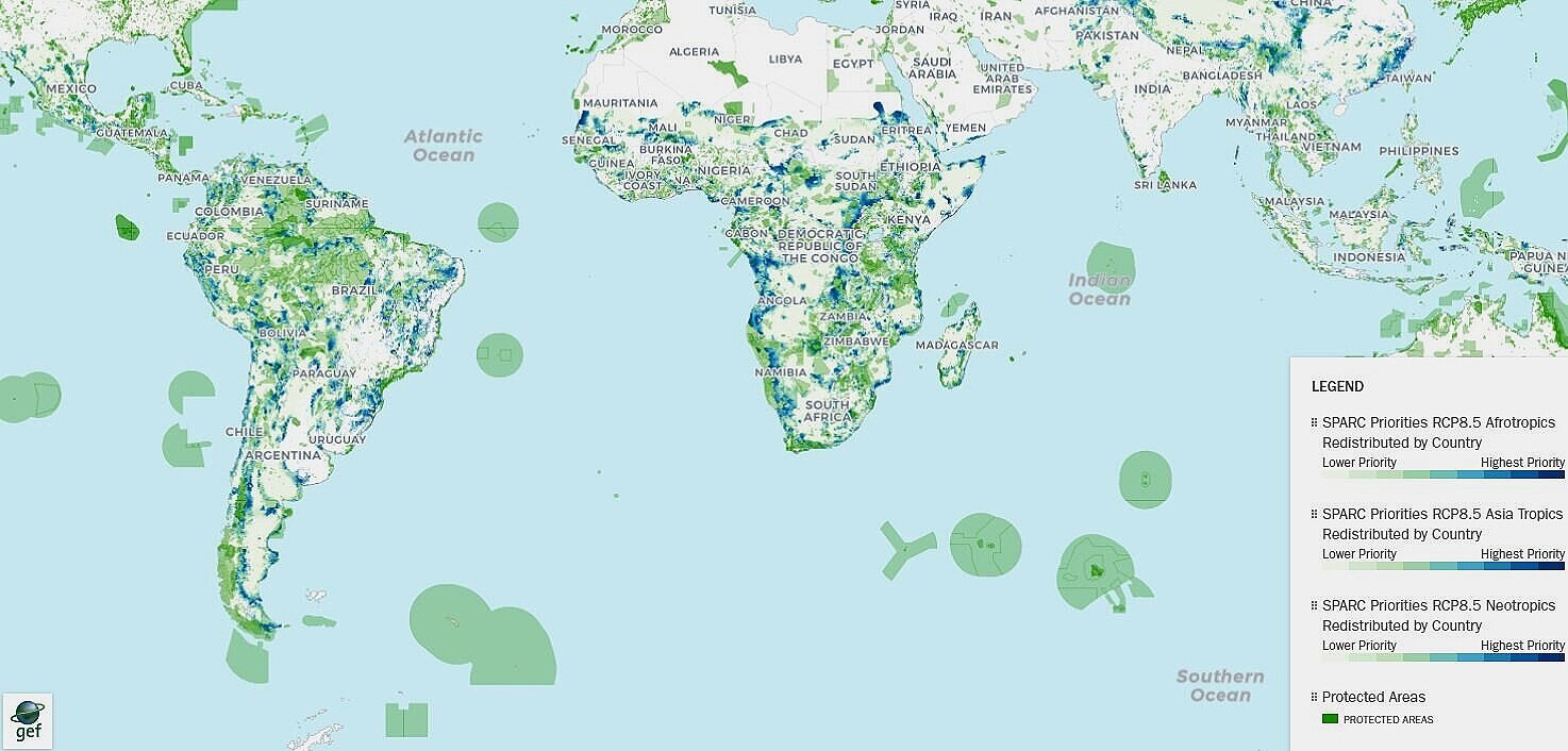
Explore Biodiversity Conservation Priorities — Interactively
The SPARC Irrecoverable Carbon & Biodiversity Explorer puts our science directly in your hands. Developed with conservation partners, it lets anyone — scientist, policymaker, or funder — zoom into any region on Earth and immediately see where irreplaceable biodiversity and carbon overlap, where protection is most urgent, and what is at stake if action is delayed.
This is not a static map. It is a live decision-support tool built from hundreds of millions of biodiversity records and cutting-edge spatial prioritization models.
Open SPARC Explorer in a new tab →
Conservation Planning
Nature does not wait for certainty. Our lab translates the best available biodiversity evidence into spatial plans that partners can act on today — while staying honest about what we do not yet know.
We combine more than 284 million plant occurrence records from the BIEN database with climate models, land-use scenarios, and range forecasts to answer the questions that matter most to conservation practitioners: Where should we protect land? Which investments reduce risk the most? How does the answer change under different climate futures?
Rather than producing a single “best” answer, we show how priorities shift across scenarios — so that partners can choose strategies that remain robust even as conditions change. This approach has directly informed global biodiversity frameworks and real-world protected-area conversations across the Americas, the tropics, and beyond.
Extinction Risk
The scale of the biodiversity crisis is not inevitable. Our research shows that the combination of ambitious climate action and strategic land conservation can cut projected extinction risk by more than half compared to a business-as-usual future.
That finding — Hannah et al. 2020 — quantifies what is at stake: protecting 30% of the right land while holding warming to approximately 2°C could prevent the majority of projected climate-driven species losses in the tropics. The choice between those two futures is a political and financial one — and science can sharpen exactly what each path costs.
Our lab focuses on making extinction risk estimates credible and decision-ready:
- We forecast vulnerability for thousands of plant species across multiple climate scenarios, making uncertainty explicit rather than hiding it inside a single projection.
- We identify which regions face compounding pressures — small ranges, rapid climate shifts, and limited existing protection — so that conservation effort can be targeted where it matters most.
- We apply these frameworks to priority groups including cacti (Pillet et al. 2022), tropical floras, and globally distributed plants, producing risk summaries that can be updated as new data and models arrive.
The bottom line: extinction risk is not a fixed number. It is a policy variable — and we can show exactly how much it changes depending on the decisions made in the next decade.
Protected Area Design
Where a protected area is placed matters as much as how much land is protected. Our research evaluates how current protected-area networks perform — and identifies where new or better-connected protection can deliver the greatest gains for species persistence, functional diversity, and long-term ecosystem resilience.
Working with global datasets and spatial prioritization tools, we ask: Which ecosystems and species remain dangerously underprotected? Which regions face the steepest climate exposure inside existing reserves? Where can targeted expansion or improved connectivity transform conservation outcomes at regional or continental scale?
This work builds directly on partnerships with the SPARC initiative, the post-2020 Global Biodiversity Framework planning process (Krieger et al. 2022), and remote-sensing-based assessments of protected-area effectiveness for climate mitigation (Duncanson et al. 2023).
Our goal is to give protected-area planners the same kind of scenario-aware, uncertainty-honest evidence that infrastructure planners routinely use for long-lived investments — because protected areas are exactly that.
Selected Examples
- SPARC — Spatial prioritization for species conservation under climate change, with map products that support partner decision-making and protected-area conversations.
- Biodiversity Framework planning — Krieger et al. 2022 argued that achieving the post-2020 Global Biodiversity Framework's ambitious goals requires inclusive, integrated spatial planning that combines biodiversity, carbon, water, and land-use objectives across sectors and scales.
- Tropical extinction risk — Hannah et al. 2020 modeled that pairing ambitious climate mitigation (≈RCP 2.6) with 30% land conservation could reduce projected climate-driven range loss — a proxy for extinction risk — by more than 50% compared to a high-emission, low-protection baseline. Results are scenario-dependent and based on species distribution models that assume approximate climate equilibrium.
- Protected-area effectiveness — Duncanson et al. 2023 evaluated the effectiveness of global protected areas for climate-change mitigation using remote-sensing biomass estimates.
- Climate risk for cacti — Pillet et al. 2022 projected elevated extinction risk of cacti under climate change using species distribution models across multiple climate scenarios.
- UNESCO World Heritage biodiversity report — UNESCO & IUCN 2023 (World Heritage: a unique contribution to biodiversity conservation) estimated that more than 16,000 threatened plant species occur across UNESCO World Heritage sites — a calculation made possible by the BIEN database. The report documents that UNESCO World Heritage sites protect more than 20,000 threatened species across all major taxonomic groups. Data from BIEN were integral to the plant estimates in that analysis.
Partner With Us
Whether you represent a conservation organization, a government agency, a philanthropic foundation, or a science-policy initiative — we want to hear from you. Our lab has deep experience translating biodiversity data into planning-ready evidence, and we are actively seeking collaborations that connect rigorous science to real-world conservation decisions.
We can support spatial prioritization, extinction risk assessment, scenario analysis, protected-area evaluation, and decision-support tool development. We are especially interested in partnerships that center equity, long-term data stewardship, and open science.
Get in touch →This page connects to the lab's broader research program and its open resources. For ongoing collaboration examples and partner-facing initiatives, see collaborators.